 Podcast
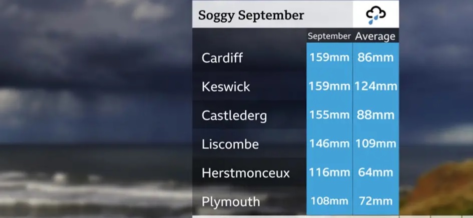
Shiva K Dhakal
National Press Corporation(NPC)
United Kingdom-Heavy rainfall is forecast to persist across much of the UK over the coming days, raising concerns of flooding and significant travel disruption in some regions.
A slow-moving weather front is expected to stall over parts of Wales and northern England, bringing continuous and increasingly heavy downpours through the weekend as a new area of low pressure develops. Forecasters warn that upland areas could see as much as 100-150mm of rain, increasing the risk of localised flooding and hazardous driving conditions.
Northern Ireland, particularly the southeast, may also experience periods of wet weather, although conditions are not expected to be as severe as in recent weeks. Scotland will see wet and windy spells before conditions turn more showery and colder, with a chance of wintry showers over the highest mountains by the weekend. Meanwhile, southeast England, the Midlands and East Anglia are likely to experience warmer weather in the short term, with temperatures climbing to around 26C on Friday before cooler, wetter conditions arrive later in the weekend.
Parts of the UK have already endured almost double the usual rainfall for September. Persistent south-westerly winds from the Atlantic have driven repeated systems of low pressure into the country, soaking areas most exposed to these winds. Cardiff, for example, has already recorded more rainfall this month than across the whole of summer. Northern Ireland, northwest England and parts of southern England have also faced a notably wet start to the autumn.
Looking ahead, forecasters expect high pressure to return early next week, bringing more settled conditions with sunshine and lighter winds. However, temperatures will dip slightly below average, with the possibility of rural frost, early morning mist and fog in some areas.


Discussion about this post